/Planning & Performance
/General Planning

Flight Planning

VFR Flight Planning, Routes

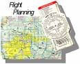
Preflight planning is a very important element of any flight and especially so when going on a cross country flight. There are a number of items to be done in preparation for a VFR cross country in such a way that nothing is overlooked and the intended flight is done as safely as possible.

The most important parts of preflight planning involve checking flight information publications, aviation weather reports and determining airplane performance, including the computation of weight and balance and fuel requirements.

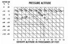
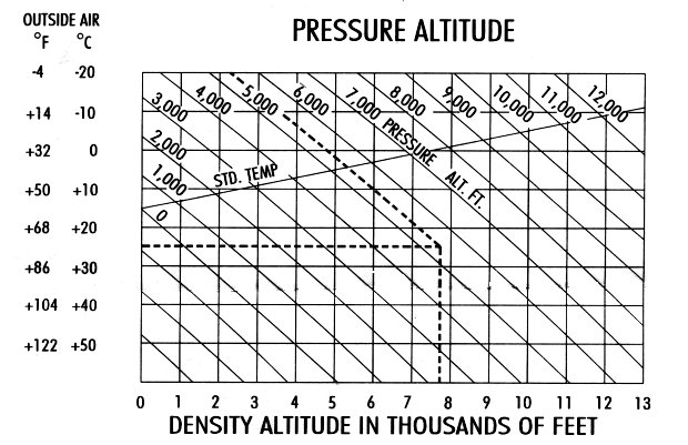
The influence of altitude, temperature and wind must not be ignored and you should be familiar with the pressure and density altitudes and the effect that they have onaircraft performance. Verifying available runway lengths and comparing them to your takeoff requirements and the rotational and initial climb speeds recommended in your airplanes manual (POH).

The checklists presented here can be used as a guide for this phase of your preflight planning and we have divided it into a couple of sections. Part one is what we call the preliminary preflight phase which can be done at any time at your leisure.

The basic steps are as follows: route selection, navigation log, weather information, fuel requirements, mass/weight & balance and performance calculations.

Route Selection

Be sure to read the tips from EuroControl aboutVFR flight preparationandvisual navigation, then the items to do any time before the flight are listed below.

navigation app

Flight Software

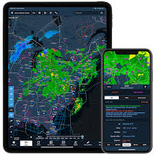
Using a navigation app is the new modern way of flying but do not forget the basics should technology fail, personally I fly using a iPad mini but make sure that I have a paper backup, just in case.

Online

A number fo websites provide online, in your browser, flight planning functionality.SkyVectorandVFRmap. SkyVector offers even weather layers, briefings, saving and submitting your flightplan and has worldwide VFR and IFR charts, VFRmap is only available in the U.S.

The basics

Select yourdestination airport(airport planning) and obtain aeronautical information from either one below:

  • AIP, Chart Supplement (Airport/Facility Directory) or Jeppesen (Bottlang)
  • Most aviation authorities have an Online eAIP
  • Current VFR flight charts or sectionals
  • Aviation App: ForeFlight, Garmin Pilot, Jeppesen Mobile, Avidyne IFD100, SkyDemon, PocketFMS...

Plot the legs/course on the map/sectional or navigation app:

  • Draw and highlight the course line, check for airspace restrictions
  • Determine Minimum Safe Altitude (MSA) along your route
  • Determine course limits left and right, this will help recognizing that a course correction is necessary
  • Using a protractor measure the true course per leg
  • Select acceptable checkpoints, every 10 NM or 10 min
  • Note radio navigation aids along the route to verify position and checkpoints (GPS, VOR, NDB)
  • Calculate total route distance

Obtaindeparture, destination and alternate airport information(from the AIP / Jeppesen).

A current AIP (online), Chart Supplement (Airport/Facility Directory), Jeppesen Airway Manual and the latestNOTAMsare needed to obtain:

Density Altitude ChartDensity Altitude Chart
  • Current conditions of runways and taxiways
  • Field elevation when flying in mountain areas, make sure tocalculate density altitude
  • Communication facilities, check for ATIS frequencies along route
  • Radio navigation availability
  • Important remarks as obstructions
  • Transponder codes for the FIRs
  • Other information pertinent for the FIR

From the latest VFR / Sectional charts obtain information relating to:

  • Airport layouts, circuit/pattern altitudes
  • Local terrain and obstructions along the route
  • Airspace restrictions (Controlled Airspace) along intended route
  • Check for bird sanctuary areas (min alt 1000 ft AGL)
  • Military low flying, danger (shooting ranges), restricted and other prohibited areas
Airport Runway

Fill out your preferred navigation flight log:

  • Enter departure and destination airport information
  • Draw destination airport diagram and an arrow showing the arrival direction to the airport (helps in visualizing how one arrives at the airport and how it looks from that point of view)
  • Fill out checkpoints
  • Measure and enter true course
  • Determine and entermagnetic variation
  • Measure and enter distances between checkpoints
  • Fill out distance remaining box
  • Calculate total distance

Some miscellaneous items:

  • Safety vests (strapped on during flight) or life raft / dinghies needed onboard, these items need to be serviceable
  • Some airports require crew to have a fluorescent vest when about on the apron
  • Carry your ID, license and aircraft papers, insurance etc
  • Make sure to have a good wristwatch, preferably one with UTC and local time
  • Have the correct checklist with you for the type of aircraft, know the emergency items by heart
  • Sunglasses (non polarizing) and a spare set of eyeglasses (if required)
  • Valid identification papers (visa, passport) for anyone onboard

Review anytakeoff and landing distance performancefrom the aircraft flight manual. In case of aircraft powered by two or more engines: re-check the engine inoperative procedures and one engine inoperative performance data.

Flight plans

Obtain anICAO Flight Plan(this one is active, fill in online and print it out), or aFAA Flight Plan(not in use anymore, kept here for historical purposes), it is the same as for a certified aircraft. Make sure you check theweight and balance在你走之前。

Written by EAI.


Enjoyed our Website?

Greetings.
If you enjoyed and found value in our site, consider becoming a member. With your help this website can keep growing as a source of information for all aviation enthusiasts!

Become our Patron

Thanks!